
Archive Record
Images
Metadata
Accession number |
1998.095 |
Catalog Number |
1998.095.003 |
Object Name |
Map |
Title |
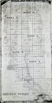
Bossier Parish Ward & School district map c. 1920 |
Caption |
Bossier Parish Ward & School district map, c 1920 |
Scope & Content |
Copy of Bossier Parish ward map, showing school district lines, levee & gravity drainage district lines. Index to Parish Assessor's Map, shows boundaries of wards and school districts. Includes towns and railroad. We also have tax assessor's roll books for Ward 6 for 1924. Locations include: Roberta Bolinger Carterville Red Land Mot Emma Plain Dealing Miller's Bluff Collinsburg Antrim Peru Cotton Belt Railway Rocky Mount Ivan Hughes Spur Alden Bridge Benton Midway Linton Bellevue Willow Chute Dukedale Vanceville Brownlee Honore Bossier City Princeton Leslie Oak Park Fillmore Haughton Oakland Koran Fullilove gin Curtis Sligo Taylortown Hunter Elm Grove McDade Atkins Poole Ninock |
Search Terms |
Alden Bridge Antrim Atkins Bellevue Benton Bolinger Bossier City Brownlee Carterville Collinsburg Cotton Belt Railroad Curtis Dukedale Elm Grove Emma Fillmore Fullilove gin Haughton Honore Hughes Spur Hunter Ivan Koran Leslie Linton McDade Midway Miller's Bluff Mot Ninock Oak Park Oakland Peru Plain Dealing Poole Princeton Red Land Roberta Rocky Mount Sligo Taylortown Vanceville Willow Chute |
Lexicon category |
8: Communication Artifact |
Imagefile |
004\1998095003-2.JPG |
Medium |
Paper |
Lexicon sub-category |
Documentary Artifact |
Inventoried date |
2024-10-10 |